« Regionalization or the art of cutting » : différence entre les versions
Aucun résumé des modifications |
|||
| Ligne 105 : | Ligne 105 : | ||
When we have this reading grid, we can distinguish the proposals more clearly, but they remain in the economic, cultural or environmental field: | When we have this reading grid, we can distinguish the proposals more clearly, but they remain in the economic, cultural or environmental field: | ||
*'''Environmental field''': we are looking to create bioregions | *'''Environmental field''': we are looking to create bioregions | ||
**'''Principe de complémentarité''' : on s’intéresse aux bassins versants qui réunissent des lieux qui ont des liens de complémentarité renvoyant aux fonctions hydrauliques avec des lieux en amont et des lieux en aval. Onregroupe les vallées dans un même | **'''Principe de complémentarité''' : on s’intéresse aux bassins versants qui réunissent des lieux qui ont des liens de complémentarité renvoyant aux fonctions hydrauliques avec des lieux en amont et des lieux en aval. Onregroupe les vallées dans un même ensemble. | ||
**'''Principe d’homogénéité''' : les massifs se définissent sur la base d’appartenance à un même milieu. Généralement, on considère qu’un massif est un ensemble important qui se présente sous des caractéristiques particulières valables sur sa totalité. Chaque vallée est coupée en deux. | **'''Principe d’homogénéité''' : les massifs se définissent sur la base d’appartenance à un même milieu. Généralement, on considère qu’un massif est un ensemble important qui se présente sous des caractéristiques particulières valables sur sa totalité. Chaque vallée est coupée en deux. | ||
*'''Champ économique''' : renvoi à la polarisation urbaine | *'''Champ économique''' : renvoi à la polarisation urbaine | ||
Principe de complémentaire : ce sont les bassins d’emploi, c’est l’aire de ce qui dépend et de ce qui concerne les services du centre de la ville. La ville fournit les services ou les emplois et la périphérie fournie les clients et la main-d’œuvre. Cela débouche sur des bassins d’emplois et des régions polarisées. | Principe de complémentaire : ce sont les bassins d’emploi, c’est l’aire de ce qui dépend et de ce qui concerne les services du centre de la ville. La ville fournit les services ou les emplois et la périphérie fournie les clients et la main-d’œuvre. Cela débouche sur des bassins d’emplois et des régions polarisées. | ||
| Ligne 121 : | Ligne 119 : | ||
Les documents suivants illustrent chacun à leur manière les éléments de la grille précédente. | Les documents suivants illustrent chacun à leur manière les éléments de la grille précédente. | ||
Aux États-Unis il y a des découpages territoriaux en vigueur qui sont d’origine coloniale à partir de populations européennes qui ont pris possession du continent et on très rapidement organisées le territoire en entités politiques et administratives. Pour cela on procède à un découpage de l’espace par des frontières et des limites géométriques qui paraissent arbitraires et ne reposent pas sur la réalité topographique et ethnographique. Ce type de découpage ne représente pas les évidences régionales. | Aux États-Unis, il y a des découpages territoriaux en vigueur qui sont d’origine coloniale à partir de populations européennes qui ont pris possession du continent et on très rapidement organisées le territoire en entités politiques et administratives. Pour cela on procède à un découpage de l’espace par des frontières et des limites géométriques qui paraissent arbitraires et ne reposent pas sur la réalité topographique et ethnographique. Ce type de découpage ne représente pas les évidences régionales. | ||
[[Fichier:Malcom wells1.png|300px|vignette|centré]] | [[Fichier:Malcom wells1.png|300px|vignette|centré]] | ||
Version du 18 juillet 2018 à 19:00
| Professeur(s) | Frédéric Giraut [1][2][3][4][5][6][7][8][9][10] |
|---|---|
| Cours | Introduction à la géographie : du local au global |
Lectures
- Introduction à la géographie : du local au mondial
- L’Afrique du Sud : la géographie au pouvoir
- Ville et Urbanisation
- La régionalisation ou l’art de la découpe
- La frontière : un objet fétiche de la géographie politique, des formes et des effets fluctuants
- Relations centre – périphérie en géographie
- Toponymie : l’étude des noms de lieux en géographie politique
This theme refers to regionalisation operations, i.e. geographical division. For several decades, geography has applied a method of clever territorial division. Geography has become the science of the distribution and division of space in a coherent way.
For a long time, geography was a descriptive discipline that tried from the end of the 19th century to become an explanatory science. After the unfortunate adventure of determinism, geography came closer to a descriptive posture by developing methods of regional divisions. Notably, this was done by the French regional geography school of Paul Vidal de la Blache.
It was a question of describing in more rigorous terms than to function in simple inventory, but by proposing relevant divisions of space. Cut-outs at all scales were produced.
Because of its specialization in this exercise, geography has been called upon as an expert discipline to cut out areas considered relevant and for which it is possible to seize it as an administrative entity or a State-Sovereign type. Thus we move from a learned expertise to an expertise at the service of politics to build political territories.
Proposal for an imperative regionalisation
The establishment of the postapartheid provincial map
At the very beginning of the 1990s, apartheid came to an end with a transitional regime and the establishment of a true democracy.
During these few years of transition, one of the imperatives was to dismantle the apartheid legislative apparatus. One of the major problems is to get rid of the South African map at the regional level based on a two-space space: the one that derives from the British colonial heritage (Cape and Natal) and the Boer republics (Orange Free State and Western Cap) and the one unlocking Bantustans as well as entities totally dependent on the South African economy.
The transitional regime must get rid of this card. To produce a new map in provinces of equivalent status, the transitional regime will set up a think tank: does South Africa have to be a federal entity or a centralized entity? The idea is to produce a coherent map and equivalent statutes.
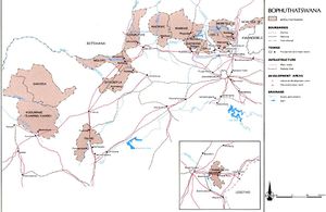
This map is that of Bophuthatswana, which is caricatured and made up of many entities that prevent a sovereign state from lasting. However, a platinum mine and a leisure park near Johannesburg and Pretoria have been transferred: the latter transfer stems from the fact that the puritanical spirit of the Afrikaners prevented gambling on their territory, hence the usefulness of the Bantustans for this trade. One city was also transferred, but was not located in a viable space to exercise authority.
In 1994, there was an attempted coup d'état by Afrikaner militias who wanted to impose an authority in a Bantustan in favour of maintaining the Bantustans.
The commission has proposed three contributions, some of which come from geographers who refer to regional division principles.
The functionalist option
This option is based primarily on areas of urban polarization.
This map shows the former Bantustan boundaries as well as lines representing regional ensembles polarized by a city. We start from the existence of a certain number of cities which exert a polarization, this city has rare services. The identification of this urban polarization makes it possible to identify the main functional regions.
In other words, there is a city that polarizes a region. The card can therefore be given almost automatically, which does not require any arbitration.
The following map shows all the agglomerations that can be considered as cities, i.e. with at least 10,000 agglomerate inhabitants, which give a fairly precise idea of the agglomerate population and the hierarchy of cities.
A few large cities are needed, but the large number of smaller cities makes choices more difficult. One can very well propose as a regional pole cities of reduced dimensions alone in a vast environment.
Depending on the cursor choice, the consequences can be more or less important. To reduce the weight of certain regions, cities are assigned an area of reduced polarization. For example, creating an area around East-London brings together two Bantustans, this choice leads to the proposal of a region polarized by East-London, but also polarized by the Xhosa ethnic group. If we extend this region to the one polarized by Port Elizabeth, we create a multi-ethnic region. Based on a fairly neutral, functional and objective proposal, we end up with regionalisations that can promote an ethnic region or, on the contrary, completely dismantle it.
In other words, this map proposes a regionalisation according to the poles which are the cities. We have an impression of simplicity, but in fact it is made abstraction of two possibilities which are :
- the choice of the number of large cities potentially at the heart of polarized areas
- the choice of an extension of the polarization area.
We can say that this map is not obvious and objective, which can involve arbitrariness. This map suggests that politics must make choices, but that these choices will only relate to areas that will have to be polarized.
The culturalist option: ethnolinguistic areas
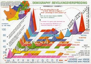
This option is based on ethnolinguistic areas. This proposal came from an organization whose objective was to promote an organization of South Africa into ethno-regional entities. This pressure group was made up of authorities from former Bantustans such as Bophuthatswana and Kwazulu, think tanks close to the far-right Afrikaners in order to perpetuate the model of great apartheid, the Inkatha FreedomParty, which is the Zulu ethnoregionist party, but also OGN, whose reference model is the promotion of development based on traditional grassroots communities that try to promote a traditionalist and communist vision.
This publicity would refer to certain situations of the early 1990s which seemed to be in conflict and whose solution was in an ethnoregionalist division. At the very beginning of the 1990s, Yugoslavia was in the midst of a crisis following the demands for independence from Slovenia, Croatia and Macedonia, and it was thought that a solution based on an ethnoregionalist division would have made it possible to settle the explosion of former Yugoslavia from a pacifist point of view, but which finally did not have the desired effect leading to war. This pressure group had as its basis this vision, a vision based on an ethnoregionalist division leading to a potential peace in order to have a new peaceful South Africa while keeping a certain rationalist vision.
This table is supposed to represent the entire South African population according to their language of origin. However, we could again aggregate these linguistic bases on other levels, this choice shows a certain categorical arbitrariness. There is an obvious arbitrariness between those who are of European origin and those who are not. Among other things, we see that Afrikaners are a more ambiguous category in terms of their ethnic identification, making it possible to propose a vast partitioning between populations.
This type of division is on the one hand questionable and on the other hand this type of division is lacking when it comes to dealing with the urban environment, because it is cosmopolitan, multi-ethnic and plurilinguistic. Thus a good part of the South African population is not ultimately concerned by this division going against the idea of creating regional entities.
In other words, this document is the scientific basis of the ethnoregionalist lobby. If we cross a set of areas and the distribution of population groups according to the criteria used we will each time have a totally dominant group. This division would be appropriate for all the communities that would represent them in majority. Thus only rural space is treated to the detriment of urban space which in reality does not allow to answer the main question.
The bioregionalist option
This is the environmental field with the bioregionalist option. Reflection and pressure groups propose alternatives to the political proposal inherited from decolonisation. These groups propose to return to the natural functioning of ecosystems and the organization of terrestrial space advocating regionalization according to environmental criteria.
This map is the creation of ethnoregionalists in order to get out of politics and let them be arbitrated by nature. They do not propose criteria related to society, but natural and environmental criteria that are in a neutral word, nature would speak for itself and would propose to get out of social problems by offloading ideology. The topographical organization of the South African space is represented: there are successive high plateaus and ranges which are escarpments which make it possible to pass from high plateaus to coastal regions by mountain massifs. There is a clear difference between the interior characterized by the plateaus and the periphery marked by the coastline.

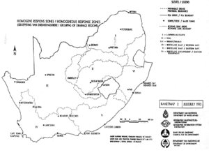
This map represents the watersheds that, once melted, will flow and join a drainage system. Each watershed leads to an ocean; some are very small and others extremely large due to rivers draining the interior of the continent. The Orange River watershed drains from Namibia and Botswana while other coastal watersheds along these escarpments drain much smaller areas.
In addition, it has phenomena of rocking of the escarpments generated by human developments in order to divert the rivers to irrigate badly drained lands. Thus, the bioregionalist organization can be rather arbitrary and truncated, one is obliged to proceed to subdivisions and territorial groupings.
On the high plateaus, in regions that are partially under water stress and arid, there have been development operations to fetch water from other catchment areas. The natural proposal is therefore the result of non-objective operations, because those who made this proposal had to subdivide the earlier Orange River proposal. Conversely, they have brought together a number of coastal watersheds.
The resulting proposal is finally based on a division close to that of the great apartheid under the cover of a truncated bioregionalist organisation.
To conclude, on the one hand regionalisation can be based on different options, on the other hand these operations are never neutral and are always carried out with trade-offs between several possibilities.
A new map: between stability, redistribution and functionalism
Finally, the transitional regime received many proposals and also came under pressure from political groups that defended certain visions and regions. A compromise map was established by retaining the idea of 8 provinces with the renewal of some states such as Orange Free State and Matale.
The other option followed is that most of the former Bantustans were distributed in several provinces. The transitional regime knew that an optimal number of regions was needed, and ultimately arbitrations were made to satisfy demands and ultimately reduce political problems.
The principles of regional coherence
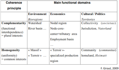
When we propose a division and regionalisation, we will always justify this proposal in the name of a principle of coherence in a particular economic, cultural or environmental field. Explicit cutting choices are made. Very often when scientists or politicians use an argument to propose regionalization, they develop the compromise argument. In reality, there are contradictory principles that we will favour and that are not compatible:
- Principle of homogeneity: regions and territories are cut out in which we will gather places which are most similar in a logic of homogeneous territory;
- Complementary principle: grouping of complementary places with complementary links.
These two opposing principles can be developed in different fields
When we have this reading grid, we can distinguish the proposals more clearly, but they remain in the economic, cultural or environmental field:
- Environmental field: we are looking to create bioregions
- Principe de complémentarité : on s’intéresse aux bassins versants qui réunissent des lieux qui ont des liens de complémentarité renvoyant aux fonctions hydrauliques avec des lieux en amont et des lieux en aval. Onregroupe les vallées dans un même ensemble.
- Principe d’homogénéité : les massifs se définissent sur la base d’appartenance à un même milieu. Généralement, on considère qu’un massif est un ensemble important qui se présente sous des caractéristiques particulières valables sur sa totalité. Chaque vallée est coupée en deux.
- Champ économique : renvoi à la polarisation urbaine
Principe de complémentaire : ce sont les bassins d’emploi, c’est l’aire de ce qui dépend et de ce qui concerne les services du centre de la ville. La ville fournit les services ou les emplois et la périphérie fournie les clients et la main-d’œuvre. Cela débouche sur des bassins d’emplois et des régions polarisées.
- Principe d’homogénéité : on propose la création d’une région à vocation économique. En URSS dans le cade de la planification les autorités décidaient de la spécialisation des régions en fonction de leur spécialité,des ressources à disposition et de l’industrie déjà en place. Au niveau régional, on trouve plus récemment dans l’histoire des districts industriels, dit aussi système productif localisé, qui regroupent un ensemble de lieux spécialisés dans le même domaine donnant une notoriété à cet ensemble régional
- Champ politique-culturel : repose sur le principe d’homogénéité
- Principe de complémentarité : on cherche à représenter un morceau de société sous la forme d’une collectivité qui regroupe des entités d’origines sociales et ethniques différentes.
- Principe d’homogénéité : on est à la recherche des communautés homogènes partageant des identités communes comme le sentiment d’appartenance liée à la langue, à une histoire, etc. La communauté se dote d’une juridiction de type communautariste.
Ce tableau permet d’éclairer les enjeux et les choix. La pratique de la régionalisation et du découpage territorial est une pratique qui a à voir avec des choix politiques et qui peut être analysée à partir du décryptage des principes à disposition.
Toutes ces propositions sont objectives, mais repose sur des propositions arbitraires qui ne sont pas forcément explicitent. Elles sont faites sous couvert d’objectivité et de spécificités qui éclipse certaines alternatives. Les documents suivants illustrent chacun à leur manière les éléments de la grille précédente.
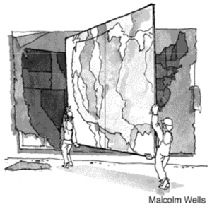
Aux États-Unis, il y a des découpages territoriaux en vigueur qui sont d’origine coloniale à partir de populations européennes qui ont pris possession du continent et on très rapidement organisées le territoire en entités politiques et administratives. Pour cela on procède à un découpage de l’espace par des frontières et des limites géométriques qui paraissent arbitraires et ne reposent pas sur la réalité topographique et ethnographique. Ce type de découpage ne représente pas les évidences régionales.
Le type de coupage rectiligne a été et est souvent critiqué comme étant arbitraire, car il ne correspondant en rien aux réalités naturelles d’une part et sociales d’autre part qui existe dans les différentes régions des États-Unis. Un mouvement biorégionaliste propose de remplacer les frontières géométriques par des frontières qui reposeraient sur des frontières soit en lien avec l’histoire précoloniale ou plus généralement soit des frontières naturelles limitant des entités régionales.
La volonté est de remplacer une carte par une autre. Même pour les ethnorégionalistes le découpage n’est pas évident, car plusieurs options se présentent :
- une option vise à identifier des régions homogènes d’un point de vue naturel ;
- une option qui vise à construire des régions qui ont une légitimité naturelle fondée sur la complémentarité en jouant sur les bassins versants.
Ainsi, on définit un certain nombre de découpages qui ne se superposent pas. Même dans le champ environnemental il n’y a pas un bon découpage régional, mais il y en a plusieurs possibles :
- option des bassins ethnographiques
- option des écorégions terrestres basée sur l’identification des régions qui rassemblent des lieux ayant des caractéristiques environnementales proches débouchant sur des paysages naturels qui sont relativement similaires.
Pour la Californie, un certain nombre de scientifiques ont été sollicités pour procéder à un découpage en biorégions. Ainsi la Californie est divisée en une dizaine de régions. Un groupe de scientifiques a proposé une combinaison de facteurs environnementaux, mais aussi topographiques avec la prise en compte d’un ensemble de bassins versants. C’est une opposition entre homogénéité et complémentarité. Cela donne un découpage critiquable, car on ne retrouve pas pleinement les bassins versants et des régions homogènes.
Cette combinaison va servir à développer une politique publique dans le domaine environnemental.
Cette carte de la Californie découpe le territoire en microrégions correspondant aux différents groupes tribaux. La cartographie de type moderne renvoie un ensemble de régions qui ne se recoupent pas et occupent tout l’espace.
Il n’y a pas une seule portion d’espace qui n’appartienne à aucune région. La pensée moderne nous a habituées à un découpage de l’espace exclusif et exhaustif de l’espace. En réalité les fonctionnements spatiaux sont beaucoup plus complexes,car aucune entité ne relève pas de plusieurs appartenances simultanées. C’était notamment le cas des sociétés dites traditionnelles à savoir les groupes tribaux qui occupait le continent américain avant l’arrivée des européens. On a une traduction du rapport à l’espace des populations indiennes selon la pensée monde. Cependant, les groupes tribaux avaient une organisation encore différente.
C’est une cartographie qui tente de rendre compte de la territorialité longtemps niée des indiens en utilisant les outils de la pensée moderne importés par les européens. On a un découpage en petites entités régionales correspondant en principe aux territoires d’appartenance des différentes tribus.
Ainsi cette carte relève du champ culturel et politique, mais aussi d’une approche homogène.
Les figures géographiques permettent d’expliquer que l’on se réfère à une entité qui a une légitimité géographique. ; c’est notamment le cas de la figure de la vallée qui est souvent utilisée afin de signifier que l’on a un espace qui a une certaine logique géographique occupée par un groupe humain, une activité ou un certain environnement.
Lorsque la figure de la vallée procède d’un découpage d’ordre politique, il ne correspond plus nécessairement à sa définition initiale.
Sur cette carte on a un ensemble de découpages de type naturel servant à mener une politique publique comme la délimitation des massifs forestiers correspondant à l’air d’intervention d’une administration spécialisée dans la gestion forestière. Ce découpage trouve sa légitimité dans la délimitation des massifs forestiers, mais en réalité c’est un découpage purement administratif qui sert à définir les aires d’intervention d’une administration.
On identifie aussi deux réserves indiennes qui chacune se réfèrent à la figure de la vallée :
- une correspond uniquement aux rives peu profondes d’une rivière ; c’est la vision minimale de la vallée avec un cours d’eau et une portion de ses rives réduite
- une correspondante qui se réfère aussi à la figure de la vallée qui s’appelle la « houppa vallée » se référant à une portion intermédiaire sur le cours de la vallée qui est un bassin intermédiaire délimitée par un carré.
On se réfère à une figure géographique qui est celle de la vallée, mais en fait on se retrouve avec des espaces d’ordre politique et administratif qui sont des arrangements à partir de la notion de vallée
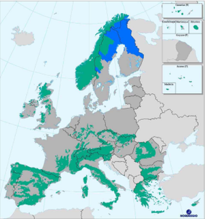
En Europe, on s’intéresse aux biorégions pour tenter de mener des politiques qui vont être adaptées à certaines caractéristiques environnementales. Au niveau, européen depuis plusieurs années on tente de définir une politique de la montage afin de déterminer les espaces qui appartiennent et n’appartiennent pas aux régions montage dans le but d’établir une politique liée à la montage.
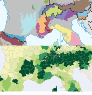
Pour se faire, une série d’étude utilise un certain nombre de critères comme la question de l’altitude et de pente afin de décréter si une localité fait partie ou non d’une région de montagne. Ce sont les seuils et les cadres spatiaux dans lesquels on va utiliser ces critères. Si on utilise un découpage municipal, on va avoir un découpage fin, mais on va trouver des municipalités de montagne qui ne rentrent pas nécessairement dans les critères.
Si on applique ces critères dans un cadre spatial plus large comme les régions ou les cantons, on va avoir tout un canton qui bascule ou pas dans les régions de montagne.
On voit que selon le niveau de généralisation on va avoir une région de montagne, ici en rose, qui englobe les 2/3 de la Suisse. Si on utilise le même critère à l’échelle des communes on voit qu’une partie du Valais échappe à la catégorie « montage ». Ainsi l’échelle de définition joue sur le découpage.
Une fois qu’on a défini ces régions de montagne, on a un vaste ensemble de type zonal qui correspondent aux montages en Europe. On peut aussi différencier les différents massifs : on a d’abord un découpage de la zone « montage » puis on différencie les massifs en plus d’utiliser les frontières nationales pour différencier les massifs selon leur appartenance à l’un ou l’autre État européen.
À l’intérieur d’une zone définie selon des citernes biorégionalistes, on va avoir un découpage interne qui va utiliser d’autres critères notamment de l’appartenance nationale. Dans les deux cas, ce sont des approches qui privilégient le principe de cohérence et d’homogénéité.
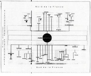
Il s’agit de l’ensemble du réseau urbain français dominé par la métropole française de Paris qui occupe une dimension centrale et importante qui lui confère une place hégémonique dans ce système de ville. Apparait un ensemble de villes disposées selon leur taille organisé selon une hiérarchie dimension nord-sud, ouest-est et finalement verticalement elles sont positionnées en fonction de leur taille.
Une métropole domine le système puis il a un sous-système régional qui domine un sous-ensemble régional. C’est une figure relativement abstraite, mais qui va permettre de procéder à des regroupements régionaux en jouant sur les niveaux de hiérarchie urbaine.
Ce type de figure qui n’est pas fréquent permet d’établir de manière explicite des choix qui sont faits lorsqu’on prétend proposer un découpage régional basé sur la polarisation urbaine. Ici, on privilégie une quinzaine de villes qui donne un découpage extraordinairement diffèrent selon les grandes régions, mais qui est déséquilibré.
Ce découpage correspond à la réalité du déséquilibre de l’organisation de l’espace français, mais ne correspond pas à la réalité administratif qui confère à paris un petit espace régional ne correspondent pas à la réalité de sa polarisation.
Cette carte de l’Allemagne a été proposée par Christaller, elle serait au plus proche de la réalité de la polarisation urbaine, c’est-à-dire organise l’Allemagne en entité fonctionnelle.
Le mode de représentation cartographique est intéressant : les entités correspondent à des cellules, c’est une sorte de tissu organique. Cette représentation cherchait à faire passer l’idée qu’une entité nationaliste est composée d’entités vivantes correspondant à des cellules vivantes, c’est une métaphore organiciste.
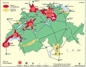
Des think tanks veulent réadapter la carte administrative suisse pour l’adapter à la fonctionnalité du territoire.
Apparait l’armature urbaine où a été ajouté les régions métropolitaines, puis en rouge des aires centrées sur une grande ville ou qui intègrent plusieurs grandes villes rejoignant les grandes agglomérations en intégrant le périurbain s’opposant à des régions ni urbaine ni métropolitaine avec des systèmes régionaux qui regroupent des villes moyennes présent dans les régions périphériques comme dans le Valais ou le Tessin. Cette organisation montre les contrastes qui existent à l’échelle de toute la Suisse entre les régions sur la base de leur caractère urbain ou non et sur la base de leur polarisation.
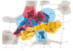
La carte suivant présente les grandes aires métropolitaines suisses. Elle ne débouche pas sur un découpage exhaustif du territoire puisqu’il n’a pas d’aire métropolitaine sur tout le territoire suisse.
À partir de là on peut effectuer des découpages. En même temps, c’est un découpage qui s’appuie sur la réalité de la polarisation.
Dans la réalité les propositions faites se gardent d’établir des fonciers fixes, car c’est dans la délimitation précise des frontières que se nichent des conflits d’ordre politique.
On préfère indiquer les grands cœurs de régions ainsi que leur nombre. Cette proposition déborde sur les espaces voisins pour montrer que ces réalités régionales contemporaines ne respectent pas forcément les frontières politique et internationale.
Cette carte montre les contrastes qui existent en termes de richesse mesurée par commune suisse. C’est une carte par anamorphose dont la taille de chaque entité correspond au nombre de leurs résidents donnant un aspect hypertrophié. Cela rend compte de la répartition de la population et des aires de richesse sachant que les communes les plus riches ne sont pas en général les éléments de centre, mais plutôt de la première couronne périphérique. Cela rend compte de contrastes qui peuvent être pertinents pour proposer une régionalisation.
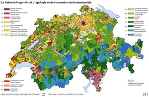
D’autres cartographies opposent les communes selon leur spécialisation économique.
On retrouve une cartographie classique ou chaque entité est représentée proportionnellement à sa superficie dont émane une typologie des activités qui montre des contrastes nets et que l’on peut procéder à des regroupements régionaux sur la base de l’homogénéité économique.
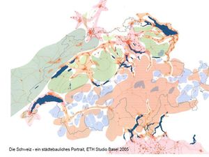
D’autres proposent une vision radicale d’un découpage de la Suisse en plusieurs entités différentes :
- Identification à l’intérieur des régions de montagne des régions de montagne qui correspondent à un marginal rural en perte de vitesse.
- Les auteurs ont isolé des « ressorts », les enclaves des régions dopées par l’activité touristique et l’immobilière en faisant un lien direct avec les populations métropolitaines et internationales qui la fréquente sans croiser la population rurale de la montage.
- On voit des zones de « silence » interstitielles entre les grandes aires métropolitaines parce qu’elles sont atones et qui sont aussi recherché par certains réside pour être dans des environnements calmes.
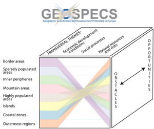
Ce graphique montre qu’au niveau européen, l’Union européenne tente d’adapter sa politique régionale a la diversité des environnements et des milieux en s‘intéressent aux territoires dit « spécifiques » :
- aires frontalières : induisent tout une série de réalités particulières
- aire peu dense : ce sont une bonne partie des régions scandinaves
- périphérie interne : fait référence aux zones interstitielles
- aire de montage
- régions très densément peuplées
- iles
- régions côtières
- régions ultras périphériques : ce sont les régions qui se situent sur d’autres continents hérités de la période coloniale
Ces catégories de territoires sont particulières d’un point de vue essentiellement environnemental et économique, mais sont difficiles à définir.
From region to territory: acceptances of a dominant concept in geography
The term territory is a widely used term today and has become dominant and hegemonic in geography. However, it is difficult to find a homogeneous definition of the term territory that can, through its implicit interpretations, lead to misunderstandings.
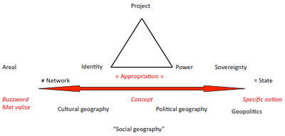
This figure tries to position the different uses of the term which gives rise to two poles that we see appearing:
- extensive use (left) of the notion with a vague definition that leaves the term to be used to designate different realities. The territory has a generic word that designates many realities. Those who use it extensively use this notion as a synonym for space and area. From the moment a phenomenon or reality exists in a space, it is considered a territory.
- restrictive use (right), it is a specific notion that can only be used in geopolitics. It refers exclusively to the area of exercise of sovereignty of the nation-state delimited by international borders.
In English, the term "territory" is used in a restrictive sense. However, the term "place" is also used to define places with a spatial extension corresponding to areas. Thus the term "territory" was used restrictively for a long time.
Today, the term tends to change definition in English, because it is inspired by a globalization effect of the Latin definition which is much broader. Since then, the term territory has an increasingly extensive use in English.
In both cases, we are not dealing with a concept that corresponds to the use of a relatively precise term to designate a set of situations. Between the two, a group of geographers uses the term territory as a concept based on the notion of appropriation: refers to a reality that has a certain spatial extension in connection with the reality of appropriation of this space by one or more social groups. In other words, this concept of territory refers to the association of one or more social groups. But the question of what defines appropriation is not seen in the same way according to the current in geography and social sciences:
- some focus on the cultural dimension
- on the political dimension
We have a cultural geography that will rather use the term territory in connection with social names and cultural appropriation related to individual identity and collective identity.
The political geography approach focuses on ownership through political control and the establishment of institutions that ensure political control.
So, in both cases we have realities that have a certain spatial extension and a phenomenon of social appropriation passing through the cultural through the construction of identities or not the political through the notion of control and the construction of institutions.
In the triangle appears the notion of project. Some researchers believe that there is territory if there is a collective project, it is notably the currents which make applied research questions of local, regional and economic development and which will be particularly attentive to the development dynamics linked to the extension of a collective project on a space.
We are in a reality that has a certain spatial extension, a phenomenon of appropriation that passes through the collective project considered an asset in terms of development are more applied approaches in terms of development and planning.
Between the extensive pole which defines little by using the word territory as a synonym for air or region, and the restrictive pole which designates the term "territory" as the space of exercise of national sovereignty delimited by borders. There are approaches that attempt to define the concept of "territory" in relation to the notion of appropriation that privileges the question of identity (cultural geography approach), control (political geography approach) or collective project (local or regional geography approach).
Among those who use the term territory extensively, some still do so as part of a conceptualization, especially those who oppose territory and network. They use the term territory extensively as a synonym for areolar phenomena, but also give it a conceptual dimension by contrasting it with the operation of a network of discontinuous identities. Jacques Levis defines the term territory in a very broad sense by systematically opposing it to network operation.
From modernity to postmodern territoriality
The term postmodernity applies to different fields. Territorial modernity is the dominant paradigm that was established during the modern period from the 16th to the 19th century, during which the world imposed itself as nation-states and colonial empires.
During this period, a paradigm imposed itself which introduces the idea that a political territory is delimited by fixed borders in time and space. On the other hand, this paradigm carries the idea that a political entity must correspond to a continuous space.
Thus, space is divided into exclusive and exhaustive entities that are the key elements of the modern paradigm of territory and political territoriality.
Principle of territorial modernity: Academic regionalization meets the political imperative of regionalization and territorialization to administer and govern the nation-state and its colonies :
- Organization in constituencies: does not allow multi-membership
- Strict interlocking with provinces made up of musicalities and states made up of provinces
- Completeness: all portions of space must belong to a territorial entity
- Fixed limits: exclusive sovereignty
- Exclusive sovereignty
How could these principles be applied to spaces whose mode of operation is significantly different?
The application of the principles of territorial modernity has a fluid space: the Nigerian Sahel.
Shale means shoreline which constitutes the shores of the Sahara and the regions which are starting and finishing points for those who embark on the crossing of the desert.
In the pre-colonial period, a certain number of exchanges developed between the southern and northern banks of the Sahara giving rise to intensive trans-Saharan trade. A road map has been set up between Sahelian cities developed thanks to trade and to pre-colonial political conceptions that favoured central cities, but also between intermediate points that are oases. Today, many of these Sahelian cities are extremists who plunder the heritage of these cities. Thus, this map shows the historical anchorage of certain cities of Sahel which are points in a space of structured course.
The borders are of colonial origin introduced inside this area which acts as a fixed border. Political constructions dominated spaces, but the defined sovereign space was not operational at that time. With European colonization, the arrival of the paradigm of territorial modernity was established with the establishment of borders that did not all have the same value:
- there are borders that delimit the area of sovereignty of different colonies within the same colonial empire;
- other borders delimit the area of sovereignty of different colonial powers.
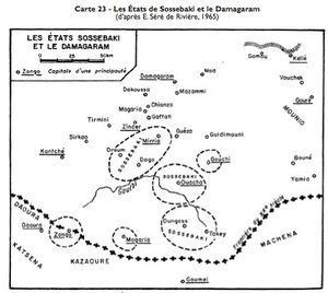
Within Nigerian space, undefined blurred areas are identified, drawing areas of different dimensions. The Sultan of Agades dominates a space that is not precisely delimited, but relatively extensive. An entity constitutive of a Tuareg empire is imposed on an area not limited, but which interferes with the sultanate of Agades. In the Sahel proper speaking, we have entities of different nature how the empire of Bornou which integrates several sultanates, within which there are spaces which do not come under its sovereignty, there is an interweaving and complexity of the territorial and political reality which cannot be reproduced according to a modern territorial representation mode.
Colonial power is faced with complex entities. Villages appear autonomous as part of a larger imperial entity, there are local principalities and cross-border principalities.
Colonization is facing these realities and will transform them from its logic of territorialization to cuts corresponding to entities of exclusive sovereignty and strictly nested in each other.
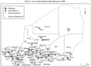
This gives a map with cantons with customary authority. Colonization will use the indirect administration technique as a concession to local societies.
In fact, it was on the one hand the only applicable modality to administer at the local level, on the other hand, these local authorities were completely reformatted by colonization to be sure that there were relay persons who would apply the colonial directives with revocation games to conform to the colonial objectives in order to rename more docile authorities.
On the other hand, there is a reformatting of the powerful entities to break them and make them correspond to the basic administration module of the colony. Where acephale-type societies had to be created, basic cantons would be created to correspond to the basic module of colonial administration.
All this is done within the framework of territorial engineering, within the framework of colonial administration technology that corresponds to the paradigm of territorial modernity. Thus, a Sahelian space transformed into a modern administered space is elaborated.
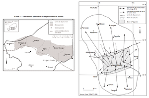
From a space of relative fluidity and a space where the variable geometry of political entities dominated, we have a grid space in exhaustive and exclusive territorial entities. There is even a zoning that was carried out between the areas reserved for rain-fed agriculture and pastoral livestock. It is the application of a very modern vision of spatial organization, we are going to have a strict zoning that will be carried out and taken over by the States that emerged from independence that finally did not correspond either to the modes of pre-colonial agrarian and pastoral organizations that were more intertwined.
In order to facilitate livestock breeding activities today, we proceed to delimited territories reserved for livestock farmers from service areas where they will find water resources and from which they will be able to travel in search of pasture.
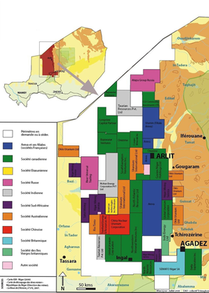
There is also a division into territorial entities corresponding to operating permits. In Niger, there is the uranium resource that has been mined by different companies and is the subject of exploration licences. Thus we have a division into limited entities that correspond to prospecting permits. This desert, which is an open space par excellence, is the subject of a division of the subsoil into narrowly defined entities.
This is how different legal and administrative procedures, others relating to the exploitation of natural resources, whether agricultural or mining, lead to a strict division of the Sahelian space, which is par excellence a space of fluidity, movement and course, but which was also a political space of entities with variable geometries.
Thus, it was possible to apply a certain logic of organization of space and representation of space corresponding to modernity territory to spaces that were part of a completely different logic of spatial and social organization.
Annexes
- Coup d’État au Niger : le président Tandja Mamadou chassé par l’armée par Emmanuel GREGOIRE - url: http://www.herodote.org/spip.php?article417
References
- ↑ Page personnelle de Frédéric Giraut sur le site de l'Université de Genève - Departement de Geographie et Environnement
- ↑ Page personnelle de Frédéric Giraut sur le site de l'Université de Genève - Gouvernance de l'Environnement et Developpement Territorial
- ↑ Publications de Frédéric Giraut diffusées sur Cairn.info
- ↑ Profile de Frédéric Giraut sur ResearchGate.net
- ↑ Profile de Frédéric Giraut syr Wikimonde.com
- ↑ Profile de Frédéric Giraut sur Google Scholar
- ↑ Page de Frédéric Giraut sur openedition.org
- ↑ Publication de Frédéric Giraut sur Liberation.fr
- ↑ Page de Frédéric Giraut sur Academia.edu
- ↑ Page de Frédéric Giraut sur these.fr
- ↑ ANNEX 10. ALCOM SADC WATER RESOURCE DATABASE presented for ALCOM by Inès Beernaerts RAFA, Accra, Ghana - url: http://www.fao.org/docrep/005/y2807e/y2807e0l.htm
- ↑ http://capausud.en-escale.com/afrique-du-sud/guide-voyage/carte-des-provinces-d-afrique-du-sud_271.html
- ↑ http://www.alta-california.com/californie_histoire.htm

