Centre - periphery relations in geography
| Professeur(s) | Frédéric Giraut [1][2][3][4][5][6][7][8][9][10] |
|---|---|
| Cours | Introduction to geography: from local to global |
Lectures
- Geography: from local to global
- South Africa: Geography in Power
- City and Urbanization
- Regionalization or the art of cutting
- The border: a fetish object of political geography, fluctuating forms and effects
- Centre - periphery relations in geography
- Toponymy: the study of place names in political geography
When we are interested in the centre - periphery relationship in geography, we are interested in the spatial dimension of these relations and in particular the relations of domination and exploitation between places.
These approaches are found at the heart of geopolitics on the one hand, and then it is also found in studies of spatial planning at different scales, namely international, local, suburban.
Definition[modifier | modifier le wikicode]
To understand this concept, elaborate definitions are necessary.
According to Christian Grataloup[11], using the notion of centre - periphery is a geometric metaphor of centre and periphery[12] which is often used to describe the opposition between the two fundamental types:
- places that have the command;
- places under command.
The fact that we speak of the relation centre-periphery refers to geometry and we must be aware that the places of commandments are not necessarily in the "middle". The center is the place of command and the periphery corresponding to the dominated place.
It is a concept that can be used at different scales. The use of this metaphor makes it possible to describe a situation by giving elements of explanation. When we speak of domination of a periphery by a centre, we will have to explain on what domination is based, either by a differential or solely by questions of the balance of power and political relations.
For the couple between centre and periphery and periphery to have meaning, there must be relationships between the two types of places that translate into links and flows that can be flows of goods, wealth, information flows, flows of people. These flows must not necessarily be unbalanced quantitatively, but at least qualitatively, and therefore this imbalance must benefit the centre, which is in a dominant position.
This system of exploitation of a periphery by the centre is dynamic and can either be reinforced over time or evolve towards an attenuation of differences and possibly an equalization between places or even an inversion of the relations of domination. Everything is theoretically possible even if the centre has a tendency to set up a system which is likely to maintain its domination even to reinforce it which is more or less effective in time.
A major author on the subject (Alain Raynaud) and an update at a time of globalization (Fred Scholz)[modifier | modifier le wikicode]
Concerning the subject of centre-periphery relations, Raynaud tried to theorise the inequalities between places and relations of domination. In his work Sociétés, Espaces, et Justice he develops the notion of socio-spatial classes. He explains that societies can be read in terms of groups that defend interests of different nature according to their position in society, but he broadens it by going contrary to the Marxist definition that uses it only on the basis of production relationships, rather one must take into account the position in society in socio-economic terms, but that within society there are other cleavages that are for example cleavages that can exist between generations. So we can also reason in terms of socio-generational, socio-sexual and socio- spatial classes. That is, depending on where you are, you will defend different interests than all the people who live or work in another place. However, this vision was rejected by the supporters of Marxist analysis who criticized the fact of putting on the same level of cleavages does not allow to take into account the positions in the production reports, it was rejected moreover because it used a terminology of the class reports which referred to Marxist analysis.
His work gives full place to the question of position in space within political relations.
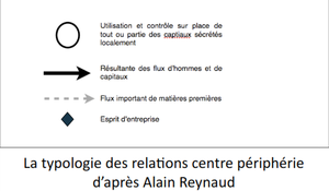
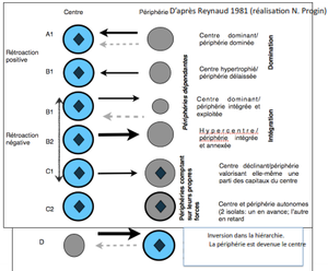
He tried to model in a relatively simplified way the whole range of relationships that can exist in center-periphery relationships at different scales. This table summarizes the different types of reports that can exist and that can possibly follow one another. The elements of legends are also called "figurative". From the moment we have a closed circle, we have a situation where we use and control on the spot part of the capital and wealth produced on the spot; this is the minimum situation so as not to be in an integral peripheral position, on the contrary, all the wealth goes back to a dominant centre that exploits. As soon as the capital is reused on the spot, we are in a situation that is not one of domination and extreme exploitation. This is the case of the centres which have almost all the wealth produced on the spot.
We have two types of arrows corresponding to capital flows and raw material flows. Finally, the author insisted on the "entrepreneurial spirit" that can only flourish in a situation that is not one of systematic exploitation.
On goes from a situation of absolute domination to a situation of reversal of flows where the old periphery becomes the centre and the old centre becomes peripheral. At the base of the system was the exploitation of natural resources, because it is the region that produces the natural resources that has become the centre, everything else goes to the benefit of the formerly dominated region that became a centre at the end of the process.
We have a situation with a drainage of natural wealth, capital and people with phenomena of rural exodus and transplantation of people of working age to the dominant region. The centre drains all the wealth and we have a totally dominated periphery. The worst situation is the situation of dominated periphery then of neglected periphery which is not necessarily based on a plundering of natural resources, but which is not necessary for the development of the centre.
In the first case, the periphery is dominated, but it is necessary to the center because it has natural wealth. In the second case, there is the drainage of wealth, but not necessary for the development of the centre. This periphery is both dominated and neglected.
Then, we arrive at situations of integrated peripheries, because there begins to be a relative distribution towards this periphery so they take place in a system that is not necessarily one-way. This is still an imbalance, but is maintained by a desire to maintain this periphery by a certain level of development and sends it a certain number of resources. These returns can be perfectly important, because we are in a phase we will have a periphery that is annexed. We go from domination to annexation, which is significantly different because when there is annexation we want to develop the periphery.
Secondly, there are stages of real development of the periphery with minimum conditions required for the development of an "entrepreneurial spirit" that leads to a situation of almost equality between the centre and the periphery.
This map is part of the opposition between the Western bloc and the Soviet bloc. An application of this reading grid on a world scale gives the establishment of two main centers, but which have integrated peripheries that are direct relays of these centers with the Western clan in which we must also locate Western Europe and Japan. A very vast periphery is dominated with different modes of relations that sometimes lead to pure and simple exploitation and sometimes lead to a kind of annexation of these peripheries with returns. For example, Cuba was both a southern space in the Soviet clan that could be considered part of the exploited spaces, notably a number of the wealth produced was drained to the USSR, but at the same time there was a significant return to this ally from the Soviet Union which was an integrated periphery and annexed by the centre.
Cette map is an attempt to represent the main cleavages that exist on a global scale in terms of wealth measured by gross national product is open to criticism, because there are states that have a high gross national product per person, but a large part of wealth is captured by a power that does not redistribute it and does not invest in infrastructure that does not translate into human development, but it is a good indicator for measuring the level of wealth.
These cleavages reflect these centre-periphery relationships. On either side of these dividing lines there are States which are either centres or peripheries annexed to the centre and which benefit from the development of the centre and on the other hand there can be peripheries dominated and exploited.
Fred Scholz developed the theory of fragmented development by focusing on the contemporary post-Cold War world in relation to the question of contemporary globalization. The main interest is that it tries not to think in terms of countries, but of places and regions. There is the idea that even on a global scale to reason in terms of countries is to erase major cleavages that may exist within countries themselves and that there are regions that are in a central position of transnational type and conversely transnational peripheries. In other words, we have large metropolises that may be close to each other, but that are located in several regions that constitute a vast region that must be associated with a certain centrality, and conversely, we have border regions that may be transnational and that are peripheral. In fact, if we think only in terms of national borders, we will miss these major divisions that exist within countries and that correspond to transnational regions. It proposes to leave the analysis solely in terms of development level by country on a global scale and seek to identify the regions or places that play a dominant role in contemporary globalisation.
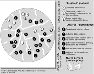
It differentiates global places from globalized places, they are globalized places that are places that participate in globalization, but do not concentrate the dominant functions that are in global places.
If we refer to Raynaud's theory, we are not in integral situations or integral centrality on a world scale. We are in an intermediate situation, this would correspond to peripheries annexed to the centre. One would have there on a world scale then the new annexed peripheries which function as relays and the new peripheries which are the dominated and neglected spaces.
What is interesting and the typology it uses is that it proposes a map that does not include international supplies, but allows to identify vast regions in central position and then conversely more or less exploited and abandoned peripheries that are transnational.
The interest of this theory is also to be applicable at different scales as to analyze the cleavages within a city.
It distinguishes global places, relays from centres and new peripheries.
As for the global locations present in these megalopolises in the south, there will be management centres, production centres linked to high technologies and finally industrial and production zones linked to the Fordist mode of production.
Among the globalized places, there are places of production or service of any other nature linked to these global activities, but which are rather places of exploitation of misery in different forms. These are all forms of exploitation of southern resources in connection with international trade. Dominated or neglected peripheries that are particularly residential to have underintegrated housing of the slum type and housing of the self-produced type that develops before the operations of servicing and connection to the main urban services.
We then have two theories, Alain Raynaud and his theory of center-periphery relations, and Scholz and his theory of fragmented development and his attempt to typology places and regions according to the relationship to contemporary globalization.
Sociospatial Justice Issues[modifier | modifier le wikicode]
Cohesion or competitiveness?[modifier | modifier le wikicode]
First of all, we need to know whether we want to favour cohesion or competitiveness and not be crossed by very important dividing lines between those who benefit from the system and those who are excluded. This works for social groups, but also for places and regions. The question of whether to give priority to the issue of cohesion or competitiveness therefore arises regularly and on a different scale.
In other words, should cohesion or competitiveness be put into practice, considering that this is a necessary condition for possible redistribution?
When we reason in geography, this question is translated into terms of priority, in terms of spatial planning and for regional development: will it be necessary to give priority to areas to strengthen their competitiveness or to give priority to peripheral marginalised regions which do not benefit from the advantages of competitive regions in order to ensure territorial cohesion and ensure that certain regions do not lag behind and do not benefit at all from the spinoffs of growth? This is an issue on all scales to define public policies and in particular it is an issue on a continental and European scale.
Should we first strengthen the regions or places that have a strong potential by sacrificing peripheral regions or first think about redistributing existing wealth to the benefit of the periphery that suffer from a certain number of disabilities. Should public services, business services and infrastructures be maintained in marginal and peripheral regions to ensure a certain territorial cohesion or should they be sacrificed in order to strengthen the metropolises which are essential places of contemporary production?
Several answers are possible as in the framework of European regional policy. The European Union, but first the European Economic Community was formed at the end of the Second World War in an attempt to create an area of cooperation and to put an end to the rivalry between nations that has been translated by two tragic conflicts.
To succeed in this model, the promoters of the European community have said to themselves that it is necessary to adopt public policies by defining a common public policy. In other words, the States agreed to transfer part of their competences; there was a rather radical attempt to create a European Union around the unification of defence policy, which was a refusal. As a result, the promoters of the European Community began with a sectoral policy in a less sensitive area.
First there was an attempt at a European coal and steel community, which was not very exciting, because uniting around a declining sector could not be sustained. That is why we decided to unite around the common agricultural policy. Since the 1970s another policy has intervened which is symbolically important and which has led to, for example, the Erasmus programme. In terms of size and budget share, this remains limited.
With the entry of the United Kingdom and Ireland, there was a new public policy which was a public policy of spatial planning. The aim was for Ireland to benefit from it under the cohesion provisions of the Treaty of Rome so that there would not be too great a divide. From 1974 onwards, it was developed on a spatial level in order to support the development of regions which had problems either because they were far behind, in a peripheral position and did not benefit from the advantages of metropolitan regions such as a large part of Ireland, or because their productive fabric was in decline.
The principle was established in the 1970s, but will take on real importance from the 1980s onwards, this time towards new members who had a level of development below the European average.
Hence the need, if we welcome these new members, to put in place a proactive policy to try to support development catch-up under cohesion. In 1984, Greece entered eastern Europe, but was separated from western Europe by central European states that were fully or partially integrated into the Soviet bloc. Regional development policy in the name of cohesion will develop considerably, with a significant proportion of the budget being transferred to regional policy.
A sophisticated system is being put in place to help in the name of regional cohesion for development.
Some regions will be eligible, these are the red Objective 1 regions. The regions whose development is lagging behind have a gross domestic product below 75% of the European average. The gross domestic product of all the Member States is calculated and if a region at a level of development below this average, it is decided that this region is eligible and will be able to benefit from development aid policy under cohesion. Objective 2 regions are industrial areas which have conversion problems because their gross domestic product is not necessarily less than 75% of the European average. The yellow areas are rural areas with problems due to the mountain environment or the remoteness of the main centres. We are in the process of putting in place a proactive public policy that is explicitly conceived as a cohesion policy. What we are helping are the regions that are experiencing development difficulties.
With the entry of new entrants who are rather rich, who have a gross domestic product above the European average. They are contributors, but they want something in return. With the Scandinavian countries we add an objective dedicated to regions which are not lagging behind in terms of gross domestic product, but which on the other hand are aware of a real problem linked to very sparsely populated regions in order to serve the population, which has an enormous cost, for extremely dispersed populations the maintenance of these services is expensive. This is a problem for the development of peripheral regions as part of cohesion.
On has an extension of the perimeter of the European Community with the entry of very many European states that were in Soviet orbit. There is an extension towards the east of the European Union. As a result, regional policy as designed needs to be rethought, as most returning states have a level of gross domestic product below the European average. If we keep the system of defining peripheral areas, the eastern regions become eligible and almost more western regions are eligible.
Some regions have seen a very significant catch-up. However, others continue to be eligible under regional policy. So are new entrants.
Regional policy is maintained in the name of cohesion, but there has been a complete shift eastwards and a problem of relocations eastwards.
Ireland has received massive European support while using policies to attract foreign direct investment. The principle of cohesion is therefore no longer the only one taken, but also the principle of competitiveness so that certain regions have some support to develop their economic fabric with a watermark the fear that the regions that receive aid will use them to set up new infrastructures and attract businesses.
It is not only an ideological shift from a Keynesian conception with a redistributive principle to a neoliberal concept, it also has the question of relocation within the European Union. Regional policy is no longer solely in the name of cohesion and no longer only benefits regions lagging behind in their development or experiencing conversion problems. We have gone from an ambitious, proactive policy that worked on the principle of cohesion to a regional policy that is always proactive, but which tries to find a balance between the issue of cohesion and competitiveness.
The World Bank published a report in 2009[13] which proposes a very spatial and geographical vision of development. At the same time, this report adopts the principles of the new geographical economy, it is a current which is interested in the assets and handicaps of the various places. Agglomerations that concentrate efficient productive fabrics enjoy a considerable advantage that is self-sustaining, the so-called agglomeration effects, the new geographical economy has tried to quantify these agglomeration effects.
The World Bank has tried to show how the South plays these agglomeration effects to the full. The first conclusion is that the cities of the south are assets for the south. Previously, the discourse was to say that these agglomerations were more problems than assets, because we have very large urban populations that do not rely on a major productive tool. We should ensure that populations are stabilized in the countryside, but do not crowd into the large cities of the south.
The other conclusion is that if we want to have significant, rapid and sustained growth in the South, we must stop dispersing efforts and focus on areas that have important assets in the context of contemporary globalization.
What is the legitimate scale for taking profits from the exploitation of natural resources?[modifier | modifier le wikicode]
In what framework should revenues from natural resource extraction be captured? When you think about the legitimate framework of annuity capture. The first question is whether natural resources are considered assets or whether they are appropriable assets.
If we believe that it is a common good, we will think that any organization that receives this pension will have to redistribute these benefits. If we consider that it is an appropriable asset, we will consider that the private actor who receives this rent is not obliged to redistribute the profits.
Something may seem obvious, it is that in any case the local, that is the place and the human group directly concerned by the extraction operations of the natural resource, it seems obvious that it must benefit from compensation because there are negative externalities and an appropriation of the place where the extraction takes place.
The principle of compensation is commonly accepted. When it comes to the question of rent, we need to know whether it should benefit the human group at the place of extraction or a wider human group which may be the region or the nation or possibly a group of nations.
We very often see claims from the local which claim the capture of the rent either as compensation or as an obvious legitimacy for the local to capture this rent. If we consider that it is a common good we can consider that it is illegitimate for the rent to be captured by the local, but that it benefits a much wider and more equitable collective of these benefits. If one is in a situation where the rent is monopolized by actors who do not want to redistribute it the logic is obvious if one is in a perspective of common good the legitimacy of the local is not obvious.
These questions may arise in different contexts such as concessions on mountain dams and hydroelectric dams.
This equipment is now coming to the end of the concession and will require significant funds for maintenance, but which can generate significant revenues, especially since today hydroelectricity can play on energy price differentials on a European scale. There are networks that have been more or less integrated and it is possible to inject electricity into a vast European network. At European level, there are states or regions that produce energy continuously, even when less energy is needed. It is the same for wind farms.
This means that we will have abundant and cheap energy and we will have hard times.
The real problem with electricity is to store what will produce electrical energy when we need it, in this case water at a height. This generates significant revenues. We can consider that the scale of legitimacy of these revenues is Europe as a whole in third because it is thanks to the integrated European system that this operation is possible.
This raises the question of whether the legitimate framework for receiving the benefits of natural extraction is the local framework. In this perspective, it would be the European scale that is legitimate to benefit from the spinoffs. This is debatable and the answer is not obvious except that it is obvious that the local must have compensation.
If they are considered common goods, the local is not in the best position to benefit from these advantages.
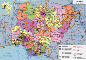
Nigeria is a very large country, it is the most populous country in Africa. It benefits from an abundance of natural resources, particularly oil. The fields exploited are mainly located in the Niger Delta. This oil is exploited for the benefit of large companies and intermediaries at the national and regional levels, which are considerably enriched with relatively little impact at the local, regional and national levels.
Conversely, negative externalities are not reduced, exploitation takes place in conditions with strong externalities with a very damaged environment in the interior delta of Niger whereas it is a very densely populated region, the ecological and social impact is very important.
Annexes[modifier | modifier le wikicode]
References[modifier | modifier le wikicode]
- ↑ Page personnelle de Frédéric Giraut sur le site de l'Université de Genève - Departement de Geographie et Environnement
- ↑ Page personnelle de Frédéric Giraut sur le site de l'Université de Genève - Gouvernance de l'Environnement et Developpement Territorial
- ↑ Publications de Frédéric Giraut diffusées sur Cairn.info
- ↑ Profile de Frédéric Giraut sur ResearchGate.net
- ↑ Profile de Frédéric Giraut syr Wikimonde.com
- ↑ Profile de Frédéric Giraut sur Google Scholar
- ↑ Page de Frédéric Giraut sur openedition.org
- ↑ Publication de Frédéric Giraut sur Liberation.fr
- ↑ Page de Frédéric Giraut sur Academia.edu
- ↑ Page de Frédéric Giraut sur these.fr
- ↑ Christian Grataloup. (2015, octobre 30). Wikipédia, l'encyclopédie libre. Page consultée le 09:30, décembre 27, 2015 à partir de http://fr.wikipedia.org/w/index.php?title=Christian_Grataloup&oldid=119996447.
- ↑ http://www.hypergeo.eu/spip.php?article10#
- ↑ World Development Report 2009 url:http://go.worldbank.org/FAV9CBBG80
