« City and Urbanization » : différence entre les versions
Aucun résumé des modifications |
Aucun résumé des modifications |
||
| (7 versions intermédiaires par le même utilisateur non affichées) | |||
| Ligne 7 : | Ligne 7 : | ||
| assistants = | | assistants = | ||
| enregistrement = | | enregistrement = | ||
| cours = [[Introduction | | cours = [[Introduction to geography: from local to global]] | ||
*[[ | | lectures = | ||
*[[ | *[[Geography: from local to global]] | ||
*[[ | *[[South Africa: Geography in Power]] | ||
*[[ | *[[City and Urbanization]] | ||
*[[ | *[[Regionalization or the art of cutting]] | ||
*[[ | *[[The border: a fetish object of political geography, fluctuating forms and effects]] | ||
*[[ | *[[Centre - periphery relations in geography]] | ||
*[[Toponymy: the study of place names in political geography]] | |||
}} | }} | ||
| Ligne 46 : | Ligne 47 : | ||
*transformation of the environment: becoming a citizen during one's life without migrating. The original environment must be transformed and considered as part of the urban environment. It is an absorption of peri-urban localities or comes from a change in status. This can be a locality that exceeds a population threshold or cities that by their expansion are absorbed into an urban agglomeration. | *transformation of the environment: becoming a citizen during one's life without migrating. The original environment must be transformed and considered as part of the urban environment. It is an absorption of peri-urban localities or comes from a change in status. This can be a locality that exceeds a population threshold or cities that by their expansion are absorbed into an urban agglomeration. | ||
== | == The city == | ||
Several criteria can be retained, they are generally associated between them: | |||
*''' | *'''morphological criterion''': we are interested in shape and appearance. We seek to identify agglomerations based on the continuity of the built environment. To consider that they are agglomerated, they must be "close to each other"; this requires the introduction of distance thresholds. | ||
*''' | *'''demographic criterion''': the number of inhabitants that make up the city | ||
*''' | *'''administrative criterion''': we try to define the administrative status of the locality as well as its limits within which we will consider the fact that the agglomeration is a city or not. Some regions can only be considered as "chief towns". | ||
*''' | *'''functional criterion''': it is the city as a functional entity such as the number of jobs (assimilation to the idea of an employment pole) or taking into account the movements that regularly exist to occupy jobs in the city (daily labour migration). The city is made up of people who hold jobs as well as outside people who hold jobs within the city. Alternating migrations make it possible to define the extension of the city independently of the morphological definition. | ||
The combination of the above criteria makes it possible to identify three main definitions of the city: | |||
*''' | *'''administrative definition''': the status of the locality is privileged and the boundaries of administrative entities define the urban perimeter. This triggers exclusion or an extensive vision of the city. | ||
Example - Touba is not considered a city in Senegal because it does not have the status of a "chief town", it is not a locality. Thus the second agglomeration of the country is excluded. This stems from a wish of the authorities to keep Touba away from the administrative power, because it is a locality in the brotherhood that the public authorities wanted to keep away from the organisation chart of its function as a religious centre. On the other hand, this locality has experienced very strong growth, which does not prevent that the official organization chart still does not integrate it. If Touba has experienced strong growth, it is for the dynamism of its activities, but mainly by the existence of a diaspora that contributes to the economic dynamics and development of the city. | |||
However, it is possible to include small administrative localities or to include an entire periphery that is part of the administrative boundaries. | |||
*'''morphological definition''': this is when physical agglomeration is favoured in association with a threshold of agglomerate populations. To do this, we must first introduce a distance threshold that marks a continuity of the building between a minimum of 50 metres and a maximum of 200 metres; we also wonder about the inclusion of a certain number of infrastructures. | |||
For example, in Switzerland the threshold of 10000 inhabitants is retained; in France the urban unit is considered when one has a morphological agglomeration characterized by a continuity of the building when one has 2000 inhabitants. | |||
*'''functional definition''': this is the integration of suburbs where urban populations reside that are independent of the city. Their populations have recourse to alternating migrations also known as "commuting" from dormitory centres to work centres. | |||
Some additional definitions: | |||
*'''suburb''': space constituted by communes within an agglomeration, but different from the city centre. This word has its origin in the medieval period, it was areas on the city bench. | |||
*'''peri-urban''' it is the environment that lies beyond the morphological agglomeration however, it depends functionally on the city | |||
*''' | *'''conurbation''': this is a variant of agglomeration, the term refers to agglomerations consisting of two or more connected agglomerations. The expansion of an agglomeration makes that another city becomes integrated creating a whole, however one distinguishes two centers. In other words, these cities have become coalescent. | ||
*''' | Example - Johannesburg which is the political capital and Pretoria which is the economic capital, by their short distance of a hundred kilometers made that one is in the presence of a conurbation. The area from Boston to Washington via New York has gradually become a vast conurbation. | ||
*'''conurbation''' : | |||
In order to understand the phenomenon of agglomerations in Switzerland, a certain number of criteria were defined, which led to the definition of Swiss agglomerations | |||
[[Fichier:Ofs zone urbain.png|300px|vignette|centré|Schuler Martin, Joye Dominique, Dessemontet Pierre ; Recensement fédéral de la population 2000. Les niveaux géographiques de la Suisse, OFS, Neuchâtel 2005. ]]In France, when there is a continuity of buildings of less than 200 metres with more than 2000 inhabitants, then we have an urban unit. According to this criterion we have between 75 and 80% of the population designated as urban. However, we will have the peri-urban environment, which is not part of the morphological agglomeration and is not considered part of the urban environment. | |||
The statistical services use the definition of urban units defined on the basis of employment poles: | |||
* | *requires a pole of employment; | ||
* | *employment pole: agglomeration within which there are more than 5000 jobs. From then on, a whole series of cities disappeared from the urban area; | ||
*inclusion of the periphery which gives weight to the urban pole. | |||
*inclusion | In the first case, the population of the agglomerations is taken into account, in the second case the peripheries are taken into account. | ||
<gallery> | <gallery> | ||
| Ligne 92 : | Ligne 86 : | ||
</gallery> | </gallery> | ||
= | = Very large cities = | ||
Several words often return in the scientific literature and the media, namely those of metropolis, megalopolis, megalopolis. They are misused as synonyms because they each have their own specificities. | |||
== | == Metropolis == | ||
It does not apply exclusively to very large cities. The term metropolis comes from ancient Greece, it meant the "mother city" i.e. the city of origin from which an enlarged entity could be constituted with the city of origin and its colonies. | |||
For a city to be considered a metropolis, it must predate other cities. Today metropolises are cities in a dominant position in relation to other cities that constitute a network of dependent cities. | |||
Example - in some federal states such as the United States there are metropolises which play an economic role, but which do not constitute complete metropolises in terms of the powers they hold, this is the case of New York compared to Washington and Pretoria compared to Johannesburg. | |||
Megacities and megacities are formed on a global scale according to a population threshold. | |||
== | == Megacities == | ||
[[Image:Los Angeles satellite map.jpg|thumb|100px| | [[Image:Los Angeles satellite map.jpg|thumb|100px|A megalopolis: satellite photo of the urban extension of Greater Los Angeles, with a 50 km promenade on the coast.]]We are talking about an agglomeration: it is a very large agglomeration on a world scale which concentrates a very high number of inhabitants. The threshold is 10 million agglomerate inhabitants, which on a world scale represents about 25 agglomerations. So it's a restrictive concept. If we retain a high threshold, it is to refer to a notion of gigantism. | ||
A more extensive conception would be to lower the threshold to 5 million, intensifying the megalopolis phenomenon. | |||
== | == Megalopolis == | ||
We designate a large remarkable region on a world scale in which we will find a very dense threshold of agglomerations that are not necessarily coalescent with often a megalopolis, other large cities and a semi of medium-sized cities. | |||
Example - the megalopolis stretching from Boston to Washington which corresponds to a succession of cities some of which are very large. Gottmann coined the term megalopolis to describe this region. He identified two other situations, namely Rhineland Europe from Rotterdam to the upstream Rhine around Basel, but also Honshu Island in Japan which integrates the Tokyo agglomeration. In the case of the Rhine megalopolis, natural geographical factors separate the areas, which makes it original. | |||
This phenomenon refers to regions that are the dynamic centres of the triad conceptualizing a global economic pole. | |||
[[Fichier:Phénomène de réflectance.jpg|400px|vignette|centré|populationdata.net]] | [[Fichier:Phénomène de réflectance.jpg|400px|vignette|centré|populationdata.net]] | ||
This reflectance phenomenon accounts for two phenomena: | |||
* | *a high concentration of the population in light-emitting areas (the Indian subcontinent, East Asia, Western Europe, North America). | ||
*However, the densest regions are not those that emit the most compared to the three poles of the triad. | |||
* | The criterion of population concentration plays a role, as does the criterion of development and wealth level. The reality of megacities also refers to the combination of these two factors. One could also speak of a megalopolis-type configuration in Brazil according to the short distance between cities; but also in Guinea and Benin independent of the level of development. | ||
[[Fichier:Agglomérations en 2000.png|400px|vignette|centré|Source : MegaCity TaskForce de l’Union géographique internationale. http://www.megacities.uni-koeln.de/documentation]] | [[Fichier:Agglomérations en 2000.png|400px|vignette|centré|Source : MegaCity TaskForce de l’Union géographique internationale. http://www.megacities.uni-koeln.de/documentation]] | ||
In this map, the threshold of 5 million inhabitants is used to define megacities, which raises the problem of official definitions and population thresholds. For example, the conurbation of Johannesburg and Pretoria exceeds 5 million inhabitants, but is not sufficiently considered by official statistical agencies and is not recognized as a megalopolis. | |||
[[Fichier:Prodoto urbano lordo.jpg|400px|vignette|centré|Il prodotto urbano lordo (PUL) - inventareilmondo.net]] | [[Fichier:Prodoto urbano lordo.jpg|400px|vignette|centré|Il prodotto urbano lordo (PUL) - inventareilmondo.net]] | ||
Here, the proportional circle is proportional to the GDP of the agglomerations. This raises the question of the attribution of production to urban and the quantification of urban activity that is not official. | |||
[[Fichier:Région urbaine de Johannesburg-Prétoria.jpg|300px|vignette|centré| | [[Fichier:Région urbaine de Johannesburg-Prétoria.jpg|300px|vignette|centré|Johannesburg-Pretoria Urban Region<ref>[http://wheb.ac-reims.fr/ressourcesdatice/DATICE/hist_geo_ed_civ/arch_bplg/archives/bul28/valleixjohannesburg.htm Ville d'apartheid, ville de ségrégation : Johannesburg] par Jean-François Valleix</ref>]] | ||
We see how an agglomeration is constituted from this map of the agglomeration of Johannesburg and Pretoria in the early 1990s. | |||
= | = Global cities = | ||
This notion emerged in the scientific literature at the beginning of the 1990s, which corresponds to the end of the Cold War and the affirmation of globalization as a reflection of the conception of the world. Saskia Sassen published The Global City in 1991: New York, London, Tokyo, Peter Taylor published World City Network: a Global Urban Analysis<ref>Taylor, P.J. (2004): World city network: a global urban analysis. London: Routledge.</ref> en 2004 et Allan Scott Global City Regions<ref>Scott, Allan J. (dir.) (2001). Global City-Regions, Trends, Theory, Policy, New York, The Oxford University, 467p.</ref> in 2001. | |||
These authors define the global city not on a dimensional threshold or on a criterion of domination of an urban network, but rather on the criterion of the functional inclusion of the city in a mechanism of globalization; it is the exercise of rare functions that play a role on a global scale: | |||
*services | *financial services (stock exchanges, rating agencies, insurance companies) ; | ||
*services | *legal services (international business law firms) ; | ||
*services | *communications services (international economic and political press) ; | ||
*services | *infrastructure services (airport hubs) ; | ||
*services | *cultural services (museums, creative sites). | ||
[[Fichier:The economist newsweek editorial offices.png|300px|vignette|centré|The Economist Newsweek editorial offices]] | [[Fichier:The economist newsweek editorial offices.png|300px|vignette|centré|The Economist Newsweek editorial offices]] | ||
This map locates a set of correspondents from a number of magazines around the world. The red dot is a permanent correspondent of The Economist, a blue dot a permanent correspondent of "Newsweek". | |||
[[Fichier: | [[Fichier:The World According to GaWC 1998.gif|400px|vignette|centré|This map illustrates the new metageography which GaWC is all about. It is an outcome of one of our early projects and details of how it was constructed can be found in [http://www.lboro.ac.uk/gawc/rb/rb5.html GaWC Research Bulletin 5]]]Here, cities are organized according to their geographical coordinates. Some cities like Geneva are considered partially global thanks to the presence of international organizations and financial services. Geneva is not a megalopolis or part of a megalopolis. | ||
The global city exists only because it is part of a global network which does not prevent some from playing a role in a hinterland like London, Hong Kong and Singapore. On the contrary, Tokyo does not play a determining role as a central place in the Asian ensemble.[[Fichier:Ville globale.png|400px|vignette|centré|source : Globalization and World Cities Research Network (GWCRN)]] | |||
= From the city to city networks = | |||
== The site-situation approach and the determinist-possibilist paradigm == | |||
We're trying to answer the question of location. The answer is in the form of a "site-situation" model developed by urban geography. First, we look at the "site" and then at the "situation". | |||
However, this model is outdated, because it refers to a possibilist-type paradigm. | |||
*determinism associates a natural environment with a type of human occupation; | |||
*possibilityism is that natural conditions offer unlimited conditions to occupy space and transform it. | |||
The site-situation approach combines the natural conditions and human occupation of a place: | |||
* | *'''site''': refers to the characteristics of the space on which a city originally developed: | ||
* | **quality of the terrain in terms of protection against natural phenomena and threats from external communities. | ||
**topographic crossing opportunities that favour sites where crossing is facilitated. | |||
*'''situation''': refers to the characteristics in terms of position occupied by the city in relation to communication routes and areas of contact between large regions. | |||
Example - Geneva: the original site (at the confluence of the Arve and the Rhône) offers possibilities in terms of crossing, but also in terms of defence with promontories in the event of crus. The situation is at the crossroads of the Rhône-Lémanian axis, it is a crossroads linking South-Eastern Europe to Central Europe via the Swiss Mitteland. | |||
== Christaller Model: Central Places Theory == | |||
This model accounts for the location of cities within a space, but the location of cities relative to each other and the development and hierarchy of each within the space. | |||
Christaller develops the theory of central places<ref>[http://fr.wikipedia.org/wiki/Walter_Christaller Walter Christaller], Die zentralen Orte in Süddeutschland, Iéna, université d'Iéna, 1933</ref> by making several hypotheses: | |||
*space is neutral: travel and exchanges are strictly equivalent; | |||
*agents will opt for actions and activities on a rational and identical basis that promotes their own interests. | |||
He wonders about the regular distribution of cities in a space according to their size. | |||
<gallery> | <gallery> | ||
Fichier:Christaller model 1.jpg|First diagram attributed to Christaller. | |||
Fichier:Christaller model 2.jpg|Second diagram attributed to Christaller. | |||
Fichier:Christaller model 3.jpg|Third scheme attributed to Christaller. | |||
</gallery> | </gallery>We see the appearance of polygons regularly nested with in their center a central square or a city likely to polarize a certain number of activities and to respond to the agents present in its space. A medium-sized polygon dominates small polygons. A large polygon polarizes medium-sized cities, which in turn polarize small cities. | ||
It is a logic of hierarchical distribution of cities in space on a regular basis around a network, however this space must be isotropic to respond to this model. | |||
Three logical principles appear: | |||
*'''market logic''': a number of services must be easily accessible. The rarest services are in a higher hierarchical order, in other words the distribution of services according to their frequency of use; | |||
*'''transport logic''': structuring of a systematically organised transport system; | |||
*'''administration logic''': results from a pyramidal spatial organization of secondary central places around a main central place. Each central location in the center of the main hex exercises administrative and political power over the secondary central locations. | |||
== City systems == | |||
*''' | *'''Urban sowing''': we are interested in the distribution of cities in space, the relations between them and the influence exerted by cities on territories. | ||
*''' | *'''Urban framework''': stresses the role of cities in the organisation of space. The term "urban framework" refers to the territorial framework of cities. The urban network emphasizes the interrelationships between cities. The city system emphasizes the relationships and interdependencies between cities. | ||
*''' | *'''Urban network''': refers to the infrastructure of roads, transport, pipelines and cables, etc. specific to an urban area. | ||
*'''System of cities''': refers to the relations that cities maintain between themselves through the routes that ensure their exchanges, the flows that reflect their intensity. | |||
== | == Rank-Size Law == | ||
An urban system is a set of cities connected to each other within a regional or international framework. They can be classified according to their rank or size according to a logarithmic law. | |||
[[Fichier:Loi rang-taille egypte.png|300px|vignette|centré]]Graphically each city is linked according to its rank and size. Information about the city network and its form appears. It is a descriptive model that makes it possible to interpret a city network. | |||
[[Fichier:Loi rang-taille | Here an imbalance appears between the head of the system and its end. The particularity lies between the first two cities and the continuation of the distribution, namely Cairo and Alexandria. We will change scale to focus on the Arab world as a whole, because Cairo and Alexandria played a central role over the long term.[[Fichier:Loi rang-taille monde arabe.png|300px|vignette|centré]]The size of Cairo and Alexandria now appears much more "normal" in this changed scale system. | ||
[[Fichier:Loi rang-taille facteurs de non linéarité.png|300px|vignette|centré]]In a federal system, we often have a set of large cities with little differentiation between them without the emergence of a super metropolis. | |||
In planned systems where the State has intervened strongly in terms of spatial planning, there will be a very large city as well as a promotion of intermediate cities. | |||
= The development of cities in the South = | |||
Cities have developed on needs that explain a call for labour from outside the city. In the south, the development of cities is linked to a phenomenon of rural exodus. | |||
The original southeast city model compared to the northern cities. We have long been trying to understand how the clustered space is organized in terms of the distribution of communities and types of population with explanations of a strictly economic nature as well as sociological explanations that highlight individual choices. | |||
The Chicago school has developed a number of models to explain the choice of locations for primomigrants based on solidarity networks. They sought to understand the logic of implementation on the basis of previously defined criteria that make it possible to account for both a static and dynamic distribution. | |||
Niger is last in the HDI ranking<ref>[http://www.undp.org/content/undp/fr/home/librarypage/hdr/africa-human-development-report-2012/ Rapport sur le développement humain en Afrique 2012 : Vers une sécurité alimentaire durable] - Programme des Nations unies pour le Développement (PNUD) </ref> despite a mineral-rich soil like Uranium. The city of Niamey in Niger is the paragon of this paradox.<gallery> | |||
<gallery> | |||
Image:Niamey SPOT 1101.jpg|Niamey vu par le satellite SPOT. | Image:Niamey SPOT 1101.jpg|Niamey vu par le satellite SPOT. | ||
Image:Niamey Niger.png|L'hotel Gaweye. | Image:Niamey Niger.png|L'hotel Gaweye. | ||
| Ligne 243 : | Ligne 215 : | ||
Image:marché Niamey.png | Image:marché Niamey.png | ||
Image:habitations Niamey.png | Image:habitations Niamey.png | ||
</gallery> | </gallery>Housing districts are based on urban self-promotion. The facility has not necessarily been formally declared or planned in advance. The informal fabric developed from an initial formal fabric. | ||
This district is a district of the densified center around an initial construction relating of a certain precariousness which is the habitat of a majority of city dwellers in a certain number of African cities. | |||
== | == Organization of the colonial city == | ||
[[Fichier:Ville coloniale dubresson.png|400px|vignette|centré|source : A. Dubresson]] | [[Fichier:Ville coloniale dubresson.png|400px|vignette|centré|source : A. Dubresson]] | ||
This model highlights four categories, but may seem static, but the part reserved for urban dynamics is present: | |||
*'''Centre''' : | *'''Centre''': the centrality comes from two historical periods, pre-colonial period in particular Muslim for North Africa colonial period: we see the development of a business district a posteriori ; | ||
*'''Habitat''' : | *'''Habitat''': there are three categories which are carried out in connection with the main axes either in a radiocentric form coupled to a sectoral model for the cities of North Africa; or for the cities of West Africa a digitized radiocentric form. | ||
**''' | **'''well-off residential''': built housing of superior quality for well-off populations, these are districts that are part of a certain planning consisting of a legal and declared housing whose land ownership is assured. The various residences are connected to water and electricity, connected to a road, connected to a set of basic services. In the North, these are only "normal modalities". | ||
**''' | **'''precarious housing estate''': ensures a certain organization of urbanization which is done by subdivision which can be done within the framework of self-promotion by populations who urbanize their space by themselves or by promoters. | ||
**''' | **'''precarious non-loti''': this is precarious, under-integrated housing which is not intended to be present in a sustainable way and to be connected to basic services without internal regularisation. | ||
*''' | *'''Equipment''' | ||
*''' | *'''Dynamics''' | ||
<gallery> | <gallery> | ||
| Ligne 266 : | Ligne 236 : | ||
</gallery> | </gallery> | ||
This model shows that the new arrivals in the rural exodus come close to the centre in the pericentral part where there is precarious and informal housing, and this in connection with the communities of origin already in the city, then they will disperse into the urban fabric by an internal redistribution that will densify the peripheral urban fabric marked by significant growth. | |||
== | == Creation of the urbanized space == | ||
We can distinguish a "normal" and legal way for the production of urbanized spaces that goes through three phases : | |||
#''' | #'''servicing''': declaration of the building space by a legal property distribution system and a technical declaration which passes by the connection to basic services (water, electricity) as well as to the road system. | ||
#'''construction''' | #'''construction''' | ||
#'''occupation''' : occupation | #'''occupation''': occupation of the building by the residents. | ||
In the southern countries, the process follows a different basic logic in two phases as in the slums: | |||
#'''occupancy''' | |||
#'''construction''': precarious type | |||
The originality of the cities of the south lies in its occupation process which explains how the different districts of the cities of the south are constituted: | |||
#'''construction''': contractors know that they cannot build within a legal framework | |||
#'''occupancy''' | |||
#'''regularisation and servicing a posteriori''': allows connections to the road network and legal land recognition | |||
[[Fichier:Composantes de la ville d' | == Davis Model: The Apartheid City == | ||
[[Fichier:Composantes de la ville d'apartheid - modèle de Davis.png|400px|vignette|centré|Les composantes de la ville d'apartheid.]]The particularity lies in the fact that parts of the city are projected out of the city according to the logic of great apartheid while urban apartheid explains this organization of the city. | |||
This model still prevails even today with the end of apartheid, when it was thought that the disappearance of segregation would restructure urban organization. One of the explanations is that the Bantustan populations are sedentary and can play on both urban and rural opportunities.[[Fichier:Composantes de la ville d'apartheid2.png|400px|vignette|centré|source : terrain 1998 - 2002<ref>Folio Fabrice. Villes post-apartheid au Kwazulu-Natal : une déclinaison du modèle de Davies. In: L'information géographique. Volume 68 n°4, 2004. pp. 320-339.</ref>]] | |||
[[Fichier: | |||
== Chicago School Model == | |||
[[Fichier:Modèles complémentaires de Burgess, Hoyt et Harris et Ullman.png|400px|vignette|centré|Les modèles complémentaires de Burgess, Hoyt et Harris et Ullman]]A distribution logic is emerging that makes it possible to identify principles of distribution and diffusion on the basis of a concentric, sectoral system and multiple nuclei. | |||
The combination of these basic models reflects the distribution of populations in urban mapping. | |||
[[Fichier:Modèles complémentaires de Burgess, Hoyt et Harris et Ullman - combinaison.png|400px|vignette|centré]] | [[Fichier:Modèles complémentaires de Burgess, Hoyt et Harris et Ullman - combinaison.png|400px|vignette|centré]] | ||
Version du 19 juillet 2018 à 20:04
| Professeur(s) | Frédéric Giraut [1][2][3][4][5][6][7][8][9][10] |
|---|---|
| Cours | Introduction to geography: from local to global |
Lectures
- Geography: from local to global
- South Africa: Geography in Power
- City and Urbanization
- Regionalization or the art of cutting
- The border: a fetish object of political geography, fluctuating forms and effects
- Centre - periphery relations in geography
- Toponymy: the study of place names in political geography
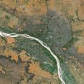
To introduce this part, we will look at a new enigma concerning the city of Touba in Senegal.


Touba is a vast agglomeration made up of small basic elements with small plots in a fabric that is not extremely dense, because they are not buildings intended for individual residences (family unit). However, there is no high population density.
Its spatial extension is important, it corresponds to an obvious internal organization with ways that structure the urban fabric introducing a link between the various districts.
The paradox lies in the fact that Touba is not one of Senegal's official cities. In fact, it refers to the very definition of the city.
Translated with www.DeepL.com/Translator
Definitions
Urbanisation
It is a process of concentration of human beings and their activities in built settlements.
Three ways to become a city dweller or "the engine of urbanization
When a human being becomes a city dweller, he contributes to urbanization:
- to be born in a city (natural growth) it is to participate in the internal growth i.e. in the natural growth of the city ;
- urban settlement (migration growth): moving from rural to urban areas through migration. This also refers to the rural exodus process;
- transformation of the environment: becoming a citizen during one's life without migrating. The original environment must be transformed and considered as part of the urban environment. It is an absorption of peri-urban localities or comes from a change in status. This can be a locality that exceeds a population threshold or cities that by their expansion are absorbed into an urban agglomeration.
The city
Several criteria can be retained, they are generally associated between them:
- morphological criterion: we are interested in shape and appearance. We seek to identify agglomerations based on the continuity of the built environment. To consider that they are agglomerated, they must be "close to each other"; this requires the introduction of distance thresholds.
- demographic criterion: the number of inhabitants that make up the city
- administrative criterion: we try to define the administrative status of the locality as well as its limits within which we will consider the fact that the agglomeration is a city or not. Some regions can only be considered as "chief towns".
- functional criterion: it is the city as a functional entity such as the number of jobs (assimilation to the idea of an employment pole) or taking into account the movements that regularly exist to occupy jobs in the city (daily labour migration). The city is made up of people who hold jobs as well as outside people who hold jobs within the city. Alternating migrations make it possible to define the extension of the city independently of the morphological definition.
The combination of the above criteria makes it possible to identify three main definitions of the city:
- administrative definition: the status of the locality is privileged and the boundaries of administrative entities define the urban perimeter. This triggers exclusion or an extensive vision of the city.
Example - Touba is not considered a city in Senegal because it does not have the status of a "chief town", it is not a locality. Thus the second agglomeration of the country is excluded. This stems from a wish of the authorities to keep Touba away from the administrative power, because it is a locality in the brotherhood that the public authorities wanted to keep away from the organisation chart of its function as a religious centre. On the other hand, this locality has experienced very strong growth, which does not prevent that the official organization chart still does not integrate it. If Touba has experienced strong growth, it is for the dynamism of its activities, but mainly by the existence of a diaspora that contributes to the economic dynamics and development of the city.
However, it is possible to include small administrative localities or to include an entire periphery that is part of the administrative boundaries.
- morphological definition: this is when physical agglomeration is favoured in association with a threshold of agglomerate populations. To do this, we must first introduce a distance threshold that marks a continuity of the building between a minimum of 50 metres and a maximum of 200 metres; we also wonder about the inclusion of a certain number of infrastructures.
For example, in Switzerland the threshold of 10000 inhabitants is retained; in France the urban unit is considered when one has a morphological agglomeration characterized by a continuity of the building when one has 2000 inhabitants.
- functional definition: this is the integration of suburbs where urban populations reside that are independent of the city. Their populations have recourse to alternating migrations also known as "commuting" from dormitory centres to work centres.
Some additional definitions:
- suburb: space constituted by communes within an agglomeration, but different from the city centre. This word has its origin in the medieval period, it was areas on the city bench.
- peri-urban it is the environment that lies beyond the morphological agglomeration however, it depends functionally on the city
- conurbation: this is a variant of agglomeration, the term refers to agglomerations consisting of two or more connected agglomerations. The expansion of an agglomeration makes that another city becomes integrated creating a whole, however one distinguishes two centers. In other words, these cities have become coalescent.
Example - Johannesburg which is the political capital and Pretoria which is the economic capital, by their short distance of a hundred kilometers made that one is in the presence of a conurbation. The area from Boston to Washington via New York has gradually become a vast conurbation.
In order to understand the phenomenon of agglomerations in Switzerland, a certain number of criteria were defined, which led to the definition of Swiss agglomerations

In France, when there is a continuity of buildings of less than 200 metres with more than 2000 inhabitants, then we have an urban unit. According to this criterion we have between 75 and 80% of the population designated as urban. However, we will have the peri-urban environment, which is not part of the morphological agglomeration and is not considered part of the urban environment.
The statistical services use the definition of urban units defined on the basis of employment poles:
- requires a pole of employment;
- employment pole: agglomeration within which there are more than 5000 jobs. From then on, a whole series of cities disappeared from the urban area;
- inclusion of the periphery which gives weight to the urban pole.
In the first case, the population of the agglomerations is taken into account, in the second case the peripheries are taken into account.


Very large cities
Several words often return in the scientific literature and the media, namely those of metropolis, megalopolis, megalopolis. They are misused as synonyms because they each have their own specificities.
Metropolis
It does not apply exclusively to very large cities. The term metropolis comes from ancient Greece, it meant the "mother city" i.e. the city of origin from which an enlarged entity could be constituted with the city of origin and its colonies.
For a city to be considered a metropolis, it must predate other cities. Today metropolises are cities in a dominant position in relation to other cities that constitute a network of dependent cities.
Example - in some federal states such as the United States there are metropolises which play an economic role, but which do not constitute complete metropolises in terms of the powers they hold, this is the case of New York compared to Washington and Pretoria compared to Johannesburg.
Megacities and megacities are formed on a global scale according to a population threshold.
Megacities

We are talking about an agglomeration: it is a very large agglomeration on a world scale which concentrates a very high number of inhabitants. The threshold is 10 million agglomerate inhabitants, which on a world scale represents about 25 agglomerations. So it's a restrictive concept. If we retain a high threshold, it is to refer to a notion of gigantism.
A more extensive conception would be to lower the threshold to 5 million, intensifying the megalopolis phenomenon.
Megalopolis
We designate a large remarkable region on a world scale in which we will find a very dense threshold of agglomerations that are not necessarily coalescent with often a megalopolis, other large cities and a semi of medium-sized cities.
Example - the megalopolis stretching from Boston to Washington which corresponds to a succession of cities some of which are very large. Gottmann coined the term megalopolis to describe this region. He identified two other situations, namely Rhineland Europe from Rotterdam to the upstream Rhine around Basel, but also Honshu Island in Japan which integrates the Tokyo agglomeration. In the case of the Rhine megalopolis, natural geographical factors separate the areas, which makes it original.
This phenomenon refers to regions that are the dynamic centres of the triad conceptualizing a global economic pole.

This reflectance phenomenon accounts for two phenomena:
- a high concentration of the population in light-emitting areas (the Indian subcontinent, East Asia, Western Europe, North America).
- However, the densest regions are not those that emit the most compared to the three poles of the triad.
The criterion of population concentration plays a role, as does the criterion of development and wealth level. The reality of megacities also refers to the combination of these two factors. One could also speak of a megalopolis-type configuration in Brazil according to the short distance between cities; but also in Guinea and Benin independent of the level of development.

In this map, the threshold of 5 million inhabitants is used to define megacities, which raises the problem of official definitions and population thresholds. For example, the conurbation of Johannesburg and Pretoria exceeds 5 million inhabitants, but is not sufficiently considered by official statistical agencies and is not recognized as a megalopolis.

Here, the proportional circle is proportional to the GDP of the agglomerations. This raises the question of the attribution of production to urban and the quantification of urban activity that is not official.

We see how an agglomeration is constituted from this map of the agglomeration of Johannesburg and Pretoria in the early 1990s.
Global cities
This notion emerged in the scientific literature at the beginning of the 1990s, which corresponds to the end of the Cold War and the affirmation of globalization as a reflection of the conception of the world. Saskia Sassen published The Global City in 1991: New York, London, Tokyo, Peter Taylor published World City Network: a Global Urban Analysis[14] en 2004 et Allan Scott Global City Regions[15] in 2001.
These authors define the global city not on a dimensional threshold or on a criterion of domination of an urban network, but rather on the criterion of the functional inclusion of the city in a mechanism of globalization; it is the exercise of rare functions that play a role on a global scale:
- financial services (stock exchanges, rating agencies, insurance companies) ;
- legal services (international business law firms) ;
- communications services (international economic and political press) ;
- infrastructure services (airport hubs) ;
- cultural services (museums, creative sites).

This map locates a set of correspondents from a number of magazines around the world. The red dot is a permanent correspondent of The Economist, a blue dot a permanent correspondent of "Newsweek".

Here, cities are organized according to their geographical coordinates. Some cities like Geneva are considered partially global thanks to the presence of international organizations and financial services. Geneva is not a megalopolis or part of a megalopolis. The global city exists only because it is part of a global network which does not prevent some from playing a role in a hinterland like London, Hong Kong and Singapore. On the contrary, Tokyo does not play a determining role as a central place in the Asian ensemble.

From the city to city networks
The site-situation approach and the determinist-possibilist paradigm
We're trying to answer the question of location. The answer is in the form of a "site-situation" model developed by urban geography. First, we look at the "site" and then at the "situation".
However, this model is outdated, because it refers to a possibilist-type paradigm.
- determinism associates a natural environment with a type of human occupation;
- possibilityism is that natural conditions offer unlimited conditions to occupy space and transform it.
The site-situation approach combines the natural conditions and human occupation of a place:
- site: refers to the characteristics of the space on which a city originally developed:
- quality of the terrain in terms of protection against natural phenomena and threats from external communities.
- topographic crossing opportunities that favour sites where crossing is facilitated.
- situation: refers to the characteristics in terms of position occupied by the city in relation to communication routes and areas of contact between large regions.
Example - Geneva: the original site (at the confluence of the Arve and the Rhône) offers possibilities in terms of crossing, but also in terms of defence with promontories in the event of crus. The situation is at the crossroads of the Rhône-Lémanian axis, it is a crossroads linking South-Eastern Europe to Central Europe via the Swiss Mitteland.
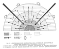
Christaller Model: Central Places Theory
This model accounts for the location of cities within a space, but the location of cities relative to each other and the development and hierarchy of each within the space.
Christaller develops the theory of central places[16] by making several hypotheses:
- space is neutral: travel and exchanges are strictly equivalent;
- agents will opt for actions and activities on a rational and identical basis that promotes their own interests.
He wonders about the regular distribution of cities in a space according to their size.

First diagram attributed to Christaller.

Second diagram attributed to Christaller.

Third scheme attributed to Christaller.


We see the appearance of polygons regularly nested with in their center a central square or a city likely to polarize a certain number of activities and to respond to the agents present in its space. A medium-sized polygon dominates small polygons. A large polygon polarizes medium-sized cities, which in turn polarize small cities.
It is a logic of hierarchical distribution of cities in space on a regular basis around a network, however this space must be isotropic to respond to this model.
Three logical principles appear:
- market logic: a number of services must be easily accessible. The rarest services are in a higher hierarchical order, in other words the distribution of services according to their frequency of use;
- transport logic: structuring of a systematically organised transport system;
- administration logic: results from a pyramidal spatial organization of secondary central places around a main central place. Each central location in the center of the main hex exercises administrative and political power over the secondary central locations.
City systems
- Urban sowing: we are interested in the distribution of cities in space, the relations between them and the influence exerted by cities on territories.
- Urban framework: stresses the role of cities in the organisation of space. The term "urban framework" refers to the territorial framework of cities. The urban network emphasizes the interrelationships between cities. The city system emphasizes the relationships and interdependencies between cities.
- Urban network: refers to the infrastructure of roads, transport, pipelines and cables, etc. specific to an urban area.
- System of cities: refers to the relations that cities maintain between themselves through the routes that ensure their exchanges, the flows that reflect their intensity.
Rank-Size Law
An urban system is a set of cities connected to each other within a regional or international framework. They can be classified according to their rank or size according to a logarithmic law.

Graphically each city is linked according to its rank and size. Information about the city network and its form appears. It is a descriptive model that makes it possible to interpret a city network. Here an imbalance appears between the head of the system and its end. The particularity lies between the first two cities and the continuation of the distribution, namely Cairo and Alexandria. We will change scale to focus on the Arab world as a whole, because Cairo and Alexandria played a central role over the long term.

The size of Cairo and Alexandria now appears much more "normal" in this changed scale system.

In a federal system, we often have a set of large cities with little differentiation between them without the emergence of a super metropolis.
In planned systems where the State has intervened strongly in terms of spatial planning, there will be a very large city as well as a promotion of intermediate cities.
The development of cities in the South
Cities have developed on needs that explain a call for labour from outside the city. In the south, the development of cities is linked to a phenomenon of rural exodus.
The original southeast city model compared to the northern cities. We have long been trying to understand how the clustered space is organized in terms of the distribution of communities and types of population with explanations of a strictly economic nature as well as sociological explanations that highlight individual choices.
The Chicago school has developed a number of models to explain the choice of locations for primomigrants based on solidarity networks. They sought to understand the logic of implementation on the basis of previously defined criteria that make it possible to account for both a static and dynamic distribution.
Niger is last in the HDI ranking[17] despite a mineral-rich soil like Uranium. The city of Niamey in Niger is the paragon of this paradox.
Niamey vu par le satellite SPOT.

L'hotel Gaweye.


Housing districts are based on urban self-promotion. The facility has not necessarily been formally declared or planned in advance. The informal fabric developed from an initial formal fabric.
This district is a district of the densified center around an initial construction relating of a certain precariousness which is the habitat of a majority of city dwellers in a certain number of African cities.
Organization of the colonial city

This model highlights four categories, but may seem static, but the part reserved for urban dynamics is present:
- Centre: the centrality comes from two historical periods, pre-colonial period in particular Muslim for North Africa colonial period: we see the development of a business district a posteriori ;
- Habitat: there are three categories which are carried out in connection with the main axes either in a radiocentric form coupled to a sectoral model for the cities of North Africa; or for the cities of West Africa a digitized radiocentric form.
- well-off residential: built housing of superior quality for well-off populations, these are districts that are part of a certain planning consisting of a legal and declared housing whose land ownership is assured. The various residences are connected to water and electricity, connected to a road, connected to a set of basic services. In the North, these are only "normal modalities".
- precarious housing estate: ensures a certain organization of urbanization which is done by subdivision which can be done within the framework of self-promotion by populations who urbanize their space by themselves or by promoters.
- precarious non-loti: this is precarious, under-integrated housing which is not intended to be present in a sustainable way and to be connected to basic services without internal regularisation.
- Equipment
- Dynamics
Source : Vennetier P, 1991 in Annales de Géographie
Source : Vennetier P, 1991 in Annales de Géographie

This model shows that the new arrivals in the rural exodus come close to the centre in the pericentral part where there is precarious and informal housing, and this in connection with the communities of origin already in the city, then they will disperse into the urban fabric by an internal redistribution that will densify the peripheral urban fabric marked by significant growth.
Creation of the urbanized space
We can distinguish a "normal" and legal way for the production of urbanized spaces that goes through three phases :
- servicing: declaration of the building space by a legal property distribution system and a technical declaration which passes by the connection to basic services (water, electricity) as well as to the road system.
- construction
- occupation: occupation of the building by the residents.
In the southern countries, the process follows a different basic logic in two phases as in the slums:
- occupancy
- construction: precarious type
The originality of the cities of the south lies in its occupation process which explains how the different districts of the cities of the south are constituted:
- construction: contractors know that they cannot build within a legal framework
- occupancy
- regularisation and servicing a posteriori: allows connections to the road network and legal land recognition
Davis Model: The Apartheid City

The particularity lies in the fact that parts of the city are projected out of the city according to the logic of great apartheid while urban apartheid explains this organization of the city. This model still prevails even today with the end of apartheid, when it was thought that the disappearance of segregation would restructure urban organization. One of the explanations is that the Bantustan populations are sedentary and can play on both urban and rural opportunities.

Chicago School Model

A distribution logic is emerging that makes it possible to identify principles of distribution and diffusion on the basis of a concentric, sectoral system and multiple nuclei.
The combination of these basic models reflects the distribution of populations in urban mapping.

Annexes
- Cours
- GLOBAL CITY-REGIONS AND THE NEW WORLD SYSTEM by Allen J. Scott
- Géographie urbaine/Site et situation des villes - Wikiversité
- Hiérarchie des villes : des « lois » taillées sur mesure - Georges NICOLAS et Anne RADEFF, Pontarlier, septembre 2012
- Égypte, tableau de bord de l’urbanisation 1950 ‐ 2020 ; http://e-geopolis.eu
- Eric Denis, 2007, « Les villes intermédiaires dans le monde arabe » Cahier du GREMAMO n°19, L’harmattan, pp. 11-54
- Moriconi-Hébrard François. Un modèle pour la croissance des systèmes urbains, la loi de la métropolisation / A growth model for urban systems, the metropolitan concentration law. In: Revue de géographie de Lyon. Vol. 73 n°1, 1998. Varia. pp. 55-70.
- Folio Fabrice. Villes post-apartheid au Kwazulu-Natal : une déclinaison du modèle de Davies. In:L'information géographique. Volume 68 n°4, 2004. pp. 320-339.
References
- ↑ Page personnelle de Frédéric Giraut sur le site de l'Université de Genève - Departement de Geographie et Environnement
- ↑ Page personnelle de Frédéric Giraut sur le site de l'Université de Genève - Gouvernance de l'Environnement et Developpement Territorial
- ↑ Publications de Frédéric Giraut diffusées sur Cairn.info
- ↑ Profile de Frédéric Giraut sur ResearchGate.net
- ↑ Profile de Frédéric Giraut syr Wikimonde.com
- ↑ Profile de Frédéric Giraut sur Google Scholar
- ↑ Page de Frédéric Giraut sur openedition.org
- ↑ Publication de Frédéric Giraut sur Liberation.fr
- ↑ Page de Frédéric Giraut sur Academia.edu
- ↑ Page de Frédéric Giraut sur these.fr
- ↑ Unités urbaines et aires urbaines - institut Veolia - unité urbaine
- ↑ Unités urbaines et aires urbaines - institut Veolia - aire urbaine
- ↑ Ville d'apartheid, ville de ségrégation : Johannesburg par Jean-François Valleix
- ↑ Taylor, P.J. (2004): World city network: a global urban analysis. London: Routledge.
- ↑ Scott, Allan J. (dir.) (2001). Global City-Regions, Trends, Theory, Policy, New York, The Oxford University, 467p.
- ↑ Walter Christaller, Die zentralen Orte in Süddeutschland, Iéna, université d'Iéna, 1933
- ↑ Rapport sur le développement humain en Afrique 2012 : Vers une sécurité alimentaire durable - Programme des Nations unies pour le Développement (PNUD)
- ↑ Folio Fabrice. Villes post-apartheid au Kwazulu-Natal : une déclinaison du modèle de Davies. In: L'information géographique. Volume 68 n°4, 2004. pp. 320-339.